
Katie KesselExplorer
An avid hiker and backpacker who most recently lived in Melbourne, Australia for four years and completed the Pacific Crest Trail in 2019.

Hike from Bells Beach to Point Addis
Bells Beach, Victoria
5.0
9.6 mi
/ 853 ft gain
Bells Beach is one of the first stops on the Great Ocean Road and an awesome spot to either surf or enjoy the small beach town vibe in the town of Torquay. Bells has some awesome storms and surges that come through so it's a great place to surf or watch the waves break.
This trail can be either hiked or run - there are some uphill climbs but nothing significant.
Park at Bells Beach and make you...

Backpack Cape Pillar
Fortescue, Tasmania
5.0
18 mi
This hike has recently been newly built with a spectacular wooden boardwalk winding in and out of the forest and along the cliffs. As with other hikes in Australia, please make sure to book your campsite prior to heading out! The Three Capes Track, a newly built four-day hike starting in Port Arthur, has recently been opened and includes portions of this older hike, though we have not yet done ...

Backpack Mt Bogong
Tawonga, Victoria
5.0
17.1 mi
/ 4219.2 ft gain
Mt Bogong sits at 1,986m and takes the crown for the highest peak in Victoria and 8th highest in Australia. The views both on the way up and at the top are amazing, especially once you pass the tree line.
This hike is not only challenging because of its length and steepness nearing the top, but lack of water for much of the year. Make sure to bring water up with you or research where to find in...

Hike to Queenstown Hill
Queenstown, New Zealand
5.0
3.1 mi
/ 1640.4 ft gain
This is a great hike while you're in Queenstown to see a gorgeous view of the area if you have a few hours to kill. The hike is very well marked with lots of information boards on the area. Please make sure to dress appropriately - there can be some snow on the ground in the winter.
From the carpark, follow the trail for around 1.5km until you reach a fork in the road. This is the beginning of ...

Explore Rottnest Island
Rottnest Island, Western Australia
5.0
Rottnest Island is probably most famous for its adorable Quokka population, but the island also has lots more to explore outside the main settlement.
With well-marked walking and biking trails both on the beach, track and road, there of tons of places to see. With trails as long as 40km, you can spend any number of hours taking your bike or walking shoes around the island. There are several ma...

Hike the Ted Errey Nature Circuit
Staughton Vale, Victoria
7.5 mi
The hike is quite well marked, identified by blue markers, but as this park has several trails that cross paths, make sure to bring your map. It is twelve kms and there are some hills, but it is overall a relatively easy hike.
There is lots of wildlife in the park, so look out for lots of beautiful birds and echidnas!
Starting at the picnic area, start the walk by heading along the management ...

Hike to Mount Rosea
Bellfield, Victoria
10.6 mi
/ 2395 ft gain
There are several different ways you can get to Mount Rosea, parking on either side of the Grampians Peaks Trail. As well, you can camp on either side (or create a longer backpacking circuit from Hall's Gap), staying at either Borough Huts or Bugiga Hikers Camp.
Starting from Borough Huts, you can park in the campground. The trail is marked and starts to the left of the campground. The hike is...

Backpack to Bugiga Hikers Camp
Halls Gap, Victoria
5.0
10.7 mi
/ 2755.9 ft gain
Starting in the town of Halls Gap, leave your car in the car park indicated on the map. From here, make your way west, away from the town and towards the forest. You will walk past the botanical gardens and wild kangaroos to the start of the trail. At the start of the trailhead, there is a fork. Follow the path right, following the signs to the Venus Baths and through the Grand Canyon. Follow t...

Hike the Coast Track from Bundeena to Wattamolla
Bundeena, New South Wales
5.0
14.9 mi
/ 1246.7 ft gain
This hike is a part of the 26km Coast Track in Royal National Park. Please note that you must purchase a parking permit from one of the visitors centres. Another option is to make this hike into a point-to-point and leave the second car at the Wattamolla day area.You can also get to Bundeena from Cronulla by ferry, walking to the start of the hike as indicated by the trailhead (as I did), which...

Hike the Cape Baily Coast Walk
Kurnell, New South Wales
4.5
5 mi
/ 492.1 ft gain
This is a great hike if you enjoy heights and looking out on the ocean, as most of the hike takes you along white rocky cliffs on the edge of the park.Given the majority of the walk is exposed, please make sure to bring sun protection and lots of water.I've started the walk at the Cape Solander carpark, however if you're in Cronulla (as I was), you can walk the 5km along the beach to the other ...

Hike to Rocky Mountain
Glendhu Bay, New Zealand
4 mi
/ 1476.4 ft gain
This is an awesome hike with views similar to Roy Peak but more varied terrain (and less of a climb as the mountain only hits 775m. The drive is only ~10 minutes outside Wanaka.
From the Diamond Lake trailhead, follow the track from the end of the car park towards Diamond Lake. From the Lake, follow the signs towards the mountain. In the first kilometer, you will see signs for the Lake Lookout....

Backpack the Cathedral Ranges
Taggerty, Victoria
5.0
7.5 mi
/ 3018.4 ft gain
This is a great hike to introduce yourself to scrambling - most of the first day is up on the ridge.I have indicated below where this can be turned into a day hike, which is what a majority of the people we met on the hike were doing. The first day took us around 5 hours (6 kms) and the second day around 2 hours (4kms). Extra time is needed on the first day - the ridge is tricky!On the first da...

Camp at Black Rocks Campground
Esk, New South Wales
3.0
This is a great place to explore - the beach is quite large and has some beautiful places to watch the waves or jump in.
There are also lots of walks such as the 8km Jerusalem Creek Walk, which you can find instructions for in the link below:
http://www.nationalparks.nsw.g...
Make sure to book ahead of time as the sites are reserved and the camp is quite popular.
Please also note that all of t...

Hike Blowhard Circuit
Devils River, Victoria
13 mi
/ 1738.8 ft gain
Starting off at the carpark, walk back the way you came about 500m until you reach Merlo's Lookout. Here, you can take in some great views of the lake before you start the summit.From the lookout, there is a trail that leads uphill directly behind you. The trail is well marked and ascends quickly up the hill. Behind you are some great views of the lake. When you reach the summit, there are some...

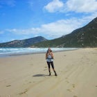
Backpack Wilson's Promontory
Wilsons Promontory, Victoria
4.5
34.4 mi
/ 5446.2 ft gain
Wilson's Promontory, or "The Prom," is one of the most famous walks in Victoria, just 3.5 hours drive outside of Melbourne. The park has diverse wildlife, including kangaroos, wallabies, koalas, emus, wombats, enchiladas, and possums. Make sure to also keep a lookout for snakes, which love to sun themselves on nice days. They won't bother you if you don't bother them!Water is not as difficult t...

Hike to the Ubirr Rock Art Sites
Kakadu, Northern Territory
1.2 mi
Kakadu National Park is one of my favourite places in Australia. Located several hundred kilometers east of Darwin in the Northern Territory, the park is 20,000 square kms of beautifully preserved wildlife and history. This part of the park is only open during the dry season, as large portions of the road are flooded from November to March. The Ubirr Rock art site is one of many places you can ...

Hike or Bike the Glendhu Bay Track
Wanaka, New Zealand
9.3 mi
This walk can also be started from the waterfront in Wanaka, which is only a few km from the track start above.
From the car park, follow the track along the lake north. It is quite well marked and follows the coastline offering stunning views of the mountains on both sides of the lake. Depending on the weather, you can often see Roy's Peak to the west of the track. Follow the track until you...

Explore Lake Clifton and the Thrombolites
Herron, Western Australia
4.0
0.4 mi
This is one of the lesser known areas that has the conditions to allow thrombolites to thrive - a biofilm on the rocks that shows you what life looked like at the dawn of time billions of years ago.The walk is quite short (600m), but there is another option to take a 5km loop walk along Lake Clifton. Start from the carpark, heading to the trail near the shelter with information on the area. Abo...

Backpack Mitchell River
Iguana Creek, Victoria
5.0
23.6 mi
/ 4986.9 ft gain
The thing I loved the most about this hike is how isolated it was. It may have been the time of year, but in the spring I saw no one else on the trail for two days, though I did see snakes, monitors, kangaroos, wallabies, wombats, and many birds. Given it was springtime, the forest was full of wildflowers. A majority of the beginning of the trail up to the first lookout was fairly overgrown, bu...

Hike the Macedon Ranges Walking Track
Mount Macedon, Victoria
5.0
11.2 mi
/ 2624.7 ft gain
The pin that has been dropped is across from the Mt Macedon Hotel, where there are many free public parking areas on the main road. If you park here (on the left side of the road coming in), you can easily circuit the walking track.The walking track can be circuited either way, but I walked the track starting on Anzac Road and finishing the summit of Mt Macedon. Please note that the track cross...

Hike to Fort Nepean
Portsea, Victoria
4.3
4.3 mi
/ 98.4 ft gain
Starting at the car park, you can choose to either head to the visitors centre (north east of the car park) to look at the information boards or you can head straight to the walk. At the visitors centre, you can arrange for a shuttle back from the fort if you wish or there are also washrooms available.Once you're ready for your walk, head to Coles Track, which starts near the Quarantine Station...

Backpack from Sheoak Falls to Sharps Track Camping Area
Lorne, Victoria
6.8 mi
/ 656.2 ft gain
The Otways National Park sits right on the Great Ocean Road, a stunning, lush park with lots of amazing tracks to explore. This track takes you through dense trees and walks along several stunning waterfalls.
Day One (4.8km)
From Sheoak car park, follow the track up the hill towards Sheoak Falls. You will reach a junction that indicates Castle Rock to the left (this is the way you will come do...

Backpack Freycinet National Park Circuit
Freycinet, Tasmania
5.0
18.1 mi
/ 2690.3 ft gain
We saw a significant amount of wildlife on this walk, so keep your eyes peeled! Wildlife that we saw included wallabies, dolphins, manta rays, and lots of beautiful birds. Also seen here are wombats, fairy penguins, and possums (though we missed these).The four day circuit can be made harder if you compress the days below, though if you can take the time I would enjoy the gorgeous beach-side ca...

Backpack from Mt Baw Baw to Mushroom Rocks
Baw Baw Village, Victoria
18.6 mi
/ 3933.7 ft gain
Please note that the weather on this walk can change drastically, so be prepared for anything! The first day on our walk was +15 and sunny and we woke up to a blanket of snow and had to walk back in freezing temperatures. Please note that, depending on the year, you may need to buy a permit to drive on the mountain. As well, you may need chains - I advise phoning if you are hiking in the should...
Community
Mobile Apps

© 2025 The Outbound Collective - Terms of Use - Privacy Policy